Drawing-up a map is the indispensable starting point for any research activity aimed towards promoting environmental policy actions. In order to ensure the effectiveness of such interventions, it is necessary to equip ourselves with a tool capable of highlighting the progressive soil deterioration occurring all over the world, as a consequence of urban and industrial development, global warming and non-sustainable agricultural activities.
For this purpose, with the Atlas of Saharan and Arabian Oases Project the LabOasis Foundation identifies 776 Oases – geo-referencing them on an interactive map which spans over the borders of 11 national states – and makes it available online. For the first time we are able to view in its entirety the constellation of Oases which has for centuries performed the task of mitigating the climate, a green defence-line crossing two deserts, a stronghold of civilisation in places where survival would appear impossible. Collected by Gismap, the data referring to geographic information has been elaborated using GIS, Remote Sensing and DBMS Open Source, in collaboration with experts from scientific bodies of different countries, especially Algeria, Egypt, Libya, Morocco, Mauritania, Niger, Tunisia. Applying our selection criteria, we located the many different settlements. We are thus able to observe changes in size occurring in the Oases, to detect silting up processes now mostly due to the decrease of water resources and to witness – however indirectly – the attachment of local communities to places made progressively inhospitable by global warming, a distinctive trait of many such communities, who clearly buck the trend of emigration as a forced choice.
The current version of the Atlas of Saharan and Arabian Oases, which shall be further developed in order to attain progressively more exhaustive classifications, is intended to provide a starting point for comparative studies of social-environmental changes in that vast area of the world characterised by extreme aridity. Studies which are necessary to elaborate those pilot interventions, which are able to implement appropriate prevention and mitigation measures, extendable to other Oases where people are facing similar emergencies. In order to document and assess the studies and the various “on the ground” projects carried out in the last 30 years – in different sectors, but all equally vital for the economy of such communities – LabOasis Foundation has also launched the Oases Database Project, linking it to the Atlas of Saharan and Arabian Oases: for each Oasis located on the map, users can access information about past, or on-going, projects and acquire details about the actors and local associations engaged in such activities.
When consulting the Database sheet, available when the Oasis – via Google Maps – is located on the Atlas map, it can be noted that many actions fostered by institutional agents, research centres and international associations, have converged in the same areas: the most accessible and famous Oases. The interactive exploration, conducted via the Atlas of Saharan and Arabian Oases, enables a deeper understanding of the local context, and the discovery of smaller and lesser-known Oases – a first step towards the formulation of intervention strategies applicable also to areas considered, until recently, to be marginal. Such areas are, in fact, home to several Oases, sitting on the edge of porous national borders drawn across the desert. These are settlements inhabited by ancient communities preserving unique hospitality traditions, indigenous culture and extraordinary historic landscapes, which not only act as a stronghold against climate change but also offer a precious contribution to the safety of the Mediterranean region, counteracting the dominance of criminal organisations in those vast uninhabited areas.
Many are, therefore, the research projects and subsequent safeguard actions we hope will be carried out on the basis of the new evidence provided by the Atlas of Saharan and Arabian Oases and the Database, notwithstanding LabOasis Foundation’s intention to contribute to their update in collaboration with experts and scholars from all around the world and, most importantly, with the ever-more needed participation of the Oases’ inhabitants.
Traditional Oasis
Our selection criteria, that is, what we mean by Oases: they consist of traditional Oases, ecosystems developed by mankind in an arid environment as early as 3,000 BC. Sites where ingenious water-capture systems made it possible to cultivate date palm trees. Oases whose original architectural heritage – today severely endangered and close to disappearing – consists of buildings made either of raw earth or stone.
Thousand-year, or hundred-year old Oases, of varying size, founded at the latest at the beginning of the XX Century, where indigenous knowledge and practices are handed down from generation to generation. In some instances we find vast areas with thousands of inhabitants scattered over various villages, in others the population is limited to 30 people, the minimum number adopted by LabOasis Foundation as its survey criteria.
The production cycle includes agriculture and pastoralism, the underlying activities for the integrated economy which is typical of the Oasis, where, in any event, date palm tree cultivation is the mainstay.
Traditional Oasis
Anthropic ecosystem found in a desert or semi-desert environment, that present similar structural features throughout the geographical area which includes the Saharan and Arabian deserts, such as:
- Presence of a human settlement and a date palm grove
- Economic and cultural key role of the date palm tree
- Climatic conditions allowing for the agriculture on three levels, typical of the Oases
- Cultivation practices which include – at least partially – traditional irrigation systems
- Presence of a traditional village or at least its vestiges, with buildings in raw earth or stone
- Stable population consisting of at least 30 inhabitants
- Settlements dating back 100 years or more
Traditional Oasis
LabOasis Foundation identifies four typologies of Traditional Oases – with specific characteristics – in order to classify the range of human settlements detected and georeferenced on the Atlas of Saharan and Arabian Oases in eleven nations in North Africa, West Africa and the Arabian Peninsula. The origins of the traditional Oasis date back to the Late Neolithic in arid and hyper arid environment. Down the line, a specific agro-pastoral economy has developed itself, based on the cultivation of the date palm tree, thanks to the evolution of sophisticated techniques of water catchment.
In order to survive in an environment that has become hostile as a result of climate change, the first inhabitants of the Oases choose four different sites where they will be able to retrieve the most precious natural resource for life: water. These are slopes and mountain terracing, or large canyons carved by prehistoric rivers, as well as seas of sand or stone, and the edges of large geological depressions, those sites which together constitute and make the hydrographic network of prehistoric times still visible today. It is indeed in each of these different contexts that is successfully devised a specific technique for the collection of the hydric resource.
LabOasis Foundation therefore offers a guideline referring to the primal heritage of knowledge and techniques of water catchment and management. Four variants defined from the hydro-geo-morphological configuration of the earth’s surface, in arid and hyper arid areas: mountain, wadi, erg, depression. Thanks to this typological classification it is possible to associate different communities, in eleven nations and in remote and distant places, on the basis of the same heritage of ancestral knowledges that has guaranteed life and prosperity across the centuries. When the hydro-geo-morphological conformation is not univocal, we will find mixed techniques of water catchment and in that case the typology attributed to that specific Traditional Oasis takes into account the prevailing original technique. It must be pointed out that the techniques of collection and the customary and communitarian management of the water resource are less and less common, given the spread of individual mechanical shafts. Hence, we often detect the presence of new hydraulic infrastructures accountable for an ecological unbalance, exacerbating the water emergency due to global warming.
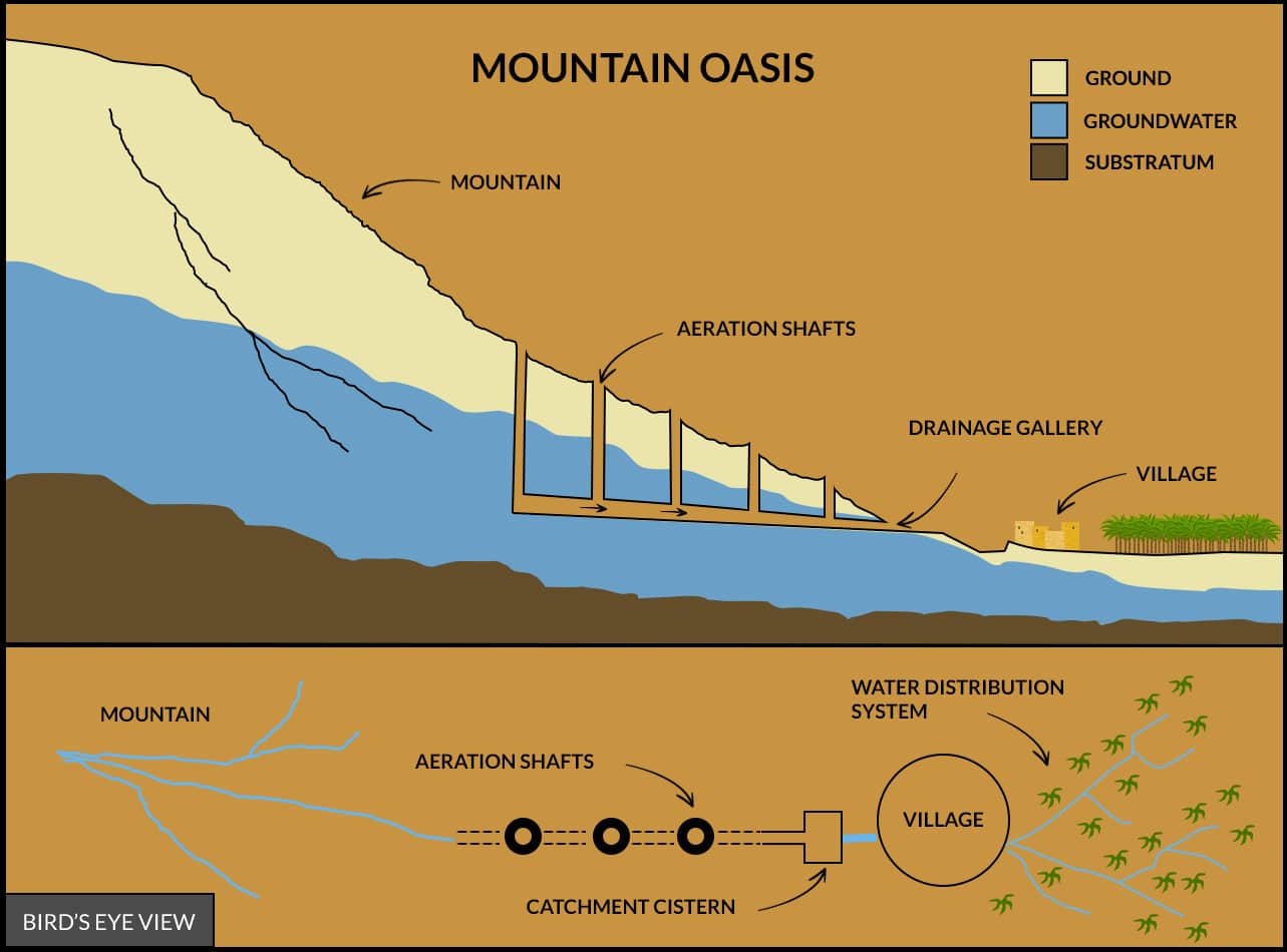
The village and the palm grove of these Traditional Oases are located halfway up a slope on terraces or at the foothill, at variable, rarely high altitudes. The typological classification as Mountain Oasis is regardless to the elevation, it concerns the water catchment system and has as its only pre-condition the presence of date palm tree cultivations, typical of the arid and hyper arid climate.
The water which allows life in the Oasis is collected by man-made underground drainage galleries with a usually rather short track. By the latter system the mountain creeks are intercepted in their downstream path, which is also a way to harness water from the permeable rock layers, infiltrated by rain that occurs on the peaks of the mountains. The drainage galleries are of reduced size when there is a consistent phreatic aquifer at foothill, and water is therefore easily obtained by wells dug at a shallow depth.
The typology of The Mountain Oasis is well represented by the Al Hajir Oasis in Oman.
This is the typology we find most frequently in the mapping carried out with the Atlas of Saharan and Arabian Oases. The village and the palm grove of these Traditional Oases are located along the shores of the ancient prehistorical rivers, today almost completely dried up: the wadis. These rivers, torrential and unpredictable, are the most visible evidence of the ancient post-glacial hydrographic network, which dried up since 4000 B.C. The millennial flow of rivers has carved large canyons or designed narrow valleys within high rocky walls, but the ancient tracks are also detectable in the sea of the big sand dunes.
In the Wadi Oases the many villages and palm groves are located on the shores of the wadi in a continuum, one after the other, marking unequivocally the track of the primeval river, even in the middle of the desert. The overall view of these settlements hence conveys the idea of a large single Oasis with a sinuous course, where small towns, villages and cultivated areas create an organic and functionally unified system. Along these shores, the oasian communities have traditionally conceived a series of canalizations supported by barriers, locks or dams. Some of these are made directly in the wadi-bed in order to catch its intermittent flows, as well as the micro steams conveyed underground. The wadis’ flash floods are known for their devasting reach, capable of causing catastrophic and unexpected floods. However, most of the wadis remain dry all year long and the supply of water in the Oasis takes place thanks to underground flows running beneath the riverbed, which is what regenerates the aquifers from which the wells draw. This is a constant underground flow which occurs thanks to rainfall taking place on the mountain ranges thousands of miles away, at the center of the Sahara, and along the Red Sea directrix Route in the Arabian desert.
When the path of the prehistoric river winds partly in the desert of sand dunes, where a shallow aquifer can be found, the typical drainage galleries of the Erg Oasis are employed. Yet another system is that of avoiding irrigation in the cultivation of the palm grove by digging large hollows called ghouts surrounded by an artificial sand dune. Interesting examples of the “oasian system”, made by an organic set of villages and cultivated areas arranged in sequence, are clearly detectable along the track of the wadi Draa, which extends for over 200 km in Morocco, or along the wadis Hadramaut in Yemen and Saoura in Algeria.
The typology of the Wadi Oasis is well represented by M Hamid El Ghizlane Oasis in Morocco.
The village and the palm grove of these Traditional Oases are located in the best-known desert landscape, the sea of sand dunes, or in the desert consisting of rocky sediments, hamada. Erg is the name of the dunes that in this context form in sequence, as sea waves carried by the wind and that can reach over 200 meters in height, for example in the Grand Erg Oriental in Algeria.
Driven by the wind and therefore in continuous motion, the sea of dunes is located where the point of convergence of many prehistoric rivers can be traced. At the origin of this morphological conformation are in fact the sandy and rocky sediments that the large waterways have transported in their bed over the millennia. In the Erg Oasis you catch water from the desert using long underground galleries to drain it from the dunes to the cultivated area. They are wide tunnels dug slightly sloping in the limestone substrates of the erg or of the hamada. They may extend for over 20 km, with air shafts perpendicular to the track, sometimes with a zigzag pattern, to maintain the speed of the outflow.
The water, that is collected and drained, comes from underground aquifers at shallow depth, as well as to a large extent from the humidity of the erg’s sand or of the hamada’s sediments. The humidity that infiltrates the sand and the rocky sediments is the result of scarce rains, but is mostly due to the condensation phenomenon. This phenomenon originates in the high temperature range night/day which is characteristic of the desert and is ingeniously exploited in the gallery. When an aquifer is at a very shallow depth, and the date palm tree can grow without irrigation due to its particular rooting apparatus, the drainage galleries are replaced by the method of cultivation providing for the excavation of ghouts, widespread in Algeria.
The typology of the Erg Oasis is well represented by the El Oued Oasis in Algeria.
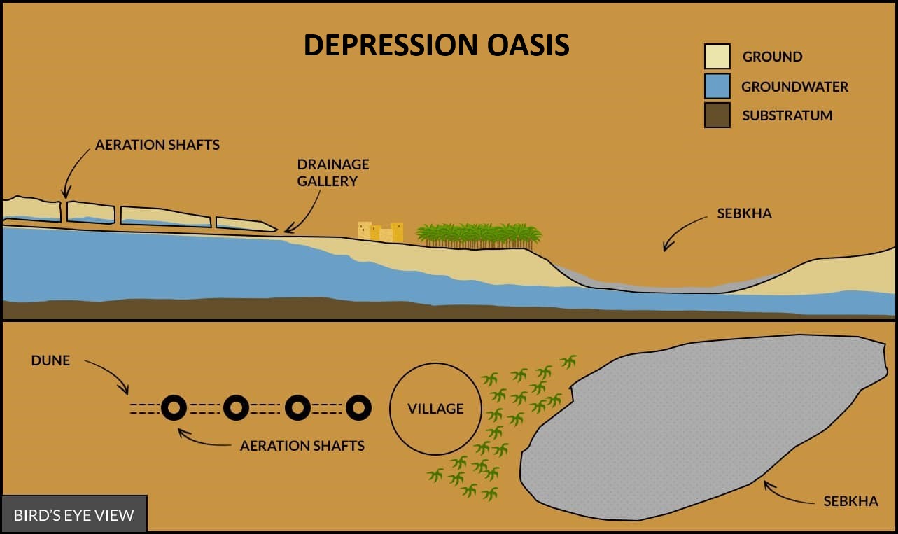
The village and the palm grove of these Traditional Oases are in some cases below sea level, however always at very low altitude. The sites where these communities have settled are in fact the shores of ancient lakes where prehistoric rivers converged when they had no outlet to the sea.
Major depressions are recurrent in the inner parts of the deserts, with at times a few lakes at the center, where water has now a very high content of salts. Most of these extended basins have instead completely arid surfaces, and are named Sebkha, or Chott if there still is some surface moisture, as it occurs, for example, in the Tunisian Jerid.
The water supply for the Oasis, is drained here by intercepting the micro-underground streams before they converge slowly, by gravitational flow, to the depression. It must be avoided they reach the underneath of the ancient lake and evaporate, releasing to the surface a thick layer of salt with dazzling reflections. Long tunnels are therefore dug, similar to those of Erg, which drain and convey water to villages and date palm groves. In some cases, the water can naturally rise from an aquifer of fossil origin and this is why a number of springs can also be found in the Oasis.
The Depression Oasis is well represented by Siwa Oasis in Egypt.
Territorial Distribution and Classification by Typology

![]()